|
Waterford Birds www.waterfordbirds.com |
|
The Waterford Breeding Bird Atlas 2006-2011 - older version 20112010 |
|
 |
|
The Waterford Breeding Bird Atlas 2006-2011
What is it? The Waterford Breeding Bird Atlas is a project to map,
at the level of 2-km x 2-km tetrads, the occurrence and status of breeding and summering birds throughout
Download 2010 pdf report (added Dec 2010) 2009 report (added Nov 2009) 2008 report national newsletter (August 2009) methods summary survey forms
Coverage update: 2010 season Fieldwork for the 5th season of the Waterford Atlas (and 2nd breeding season of the national atlas) is now completed. Known coverage in 2010 is mapped below. At least 109 tetrads (20% of county total) have had an hour or more of timed coverage so far this season, and 332 tetrads (61%) have contributed some records.
Coverage update: 2006-2010 seasons combined In total over the first 5 seasons of the Breeding Atlas at least 486 tetrads (90% of the county total) have had an hour or more of timed coverage. Of these, at least 463 tetrads (86%) have had 2+ hours, 177 (33%) 3+ hours and 77 (14%) 4+ hours of coverage. Records have been collected from at least 535 tetrads (99%) overall. Total timed coverage achieved to date has been at least 1425 hours (equivalent to about 360 half-days), additional to further (unquantified) fieldwork contributing Roving Records. See 10-km summaries for list of species and their maximum breeding status during 2008 or 2009 (Waterford Atlas data also contributing to national atlas coverage).
Tetrad
priorities & allocations for the coming seasons The maps
below show three categories of 'priority' tetrads for timed coverage (Timed Tetrad Visits) in
the final breeding seasons (2011) and indicate those which have been allocated, so far, to specific observers
for timed coverage (TTVs). In addition, Roving Records are needed from all tetrads
in the county - particularly confirmed breeding of any species, and records of scarcer or nocturnal species. Updated 1 October 2010. Priority 1: Full tetrads which have not yet had
at least 2 hours of timed coverage in 2006-10.
11 tetrads still available
(open circles below) + 32 allocated:
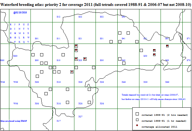
Priority 2: Full tetrads that had 2+ hours coverage
in 2006-07, but not in 2008-10, for which further coverage during the National atlas period (2008-11) will help assess
changes since 1988-91, when these tetrads were also covered. (Note: tetrads with at least 4 hours of coverage since
2006 are excluded.)
27 tetrads still available
(open squares below) + 8 allocated:
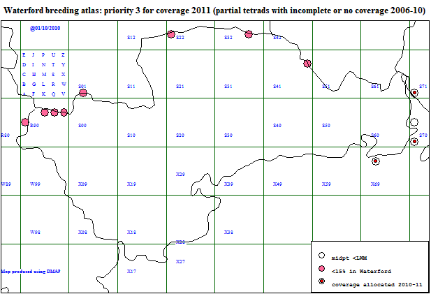
Priority 3: Partial tetrads which had no coverage,
or < 1 hr of coverage, in 2006-10; either coastal (midpoint below HWM) or border 'fragments' (with <15% of the area
in Co Waterford). These partial tetrads will require at least 1 hour of timed coverage for the Waterford atlas, but
will probably not contribute timed coverage to the National atlas (data will be submitted to latter as Roving Records).
9 tetrads still available
(full TTVs not required) + 3 allocated:
The map below shows tetrads with records of Water Rail, Woodcock, Snipe or Long-eared Owl, species that
often require targeted fieldwork at dusk or nocturnally. Tetrads checked at dusk or nocturnally but without
success are also shown. Records of other relevant species are not currently mapped - Barn Owl, Nightjar and Corncrake (to maintain site-confidentiality),
or Grasshopper Warbler (many diurnal records and some involve migrants).
. Numbers of breeding species: 2008-2010 seasons combined Numbers of possible, probable or confirmed breeding species per tetrad are mapped below, based on the latest three seasons' results (2006 & 2007 data not added yet). Migrants, non-breeders and species with unspecified breeding status (or recorded as direct fly-overs / flypasts only) are excluded. Updated 22/11/2010.
.
|
||
|
|
|||||
|
|
|||||
|
|
.
|