|
Waterford Birds www.waterfordbirds.com |
|
Winter Bird Atlas |
|
 |
|
Winter Atlas Survey: 2007/8 to 2010/11
Update: national fieldwork now completed , but records
from winters 2011/12 & 2012/13 will also be mapped for the Waterford Atlas project.
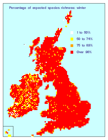
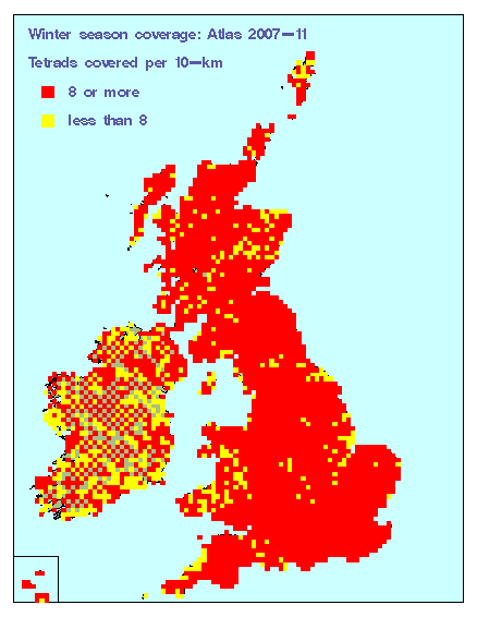
Fieldworkers in Co Waterford have contributed to this national survey (throughout Ireland and Britain) to map the distribution and relative abundance of wintering birds throughout these islands. Although results of the national atlas will be presented at 10-km scale (10-km x 10-km squares), much of the fieldwork is done at a finer scale - collecting records within 2-km x 2-km tetrads. Preliminary coverage & species maps are given below. Latest update 10 December 2011. Winter coverage update: preliminary species totals
Winter coverage update: tetrads already allocated or covered
As well
as Timed Tetrad Visits, volunteers are also needed to collect Roving Records - either in specific tetrads (e.g. near home)
or from any tetrads throughout the county. This will help build up fuller species lists for each tetrad and 10-km square.
See Bird Atlas 2007-2011, or email, to sign up. See also other maps (allocation, coverage and results) for Co Waterford, from the national atlas website (some copied below also).
Unlike
the Waterford Breeding Bird Atlas (full details here), winter atlas coverage in Waterford will not be complete, i.e. only a sample of 2-km tetrads will be surveyed fully.
(The basic requirement is 8 or more tetrads per 10-km square, or fewer in some coastal squares.) Full coverage
of a tetrads involves the Timed Tetrad Visit (TTV) method, i.e. two 1-hour counts, one during November-December
and one January-February. However, less-intensive coverage of other tetrads, using the Roving Records (RR)
method, will provide further information. If the coverage achieved by a combination of these methods is good
enough, it may be possible to produce detailed maps of winter bird distribution for selected Waterford species.
August 2009 Britain & Ireland newsletter (added 12/08/2009 2.8 mB) October 2008 national newsletter (0.9 mB) March 2008 Atlas Newsletter (added 29/03/2008) Sample species maps Maps below are based on data for the first two winters of atlas coverage (2007/08 & 2008/09).
Updated 16 December 2009.
|
||||
|
|
|
|
.
|